


Stephen R. Okkonen
Institute of Marine Science
School of Fisheries and Ocean Sciences
University of Alaska Fairbanks
Thomas C. Royer
Center for Coastal Physical Oceanography
Department of Ocean, Earth and Atmospheric Sciences
Old Dominion University
This project was made possible with the support of Polar Tankers, Inc.
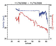
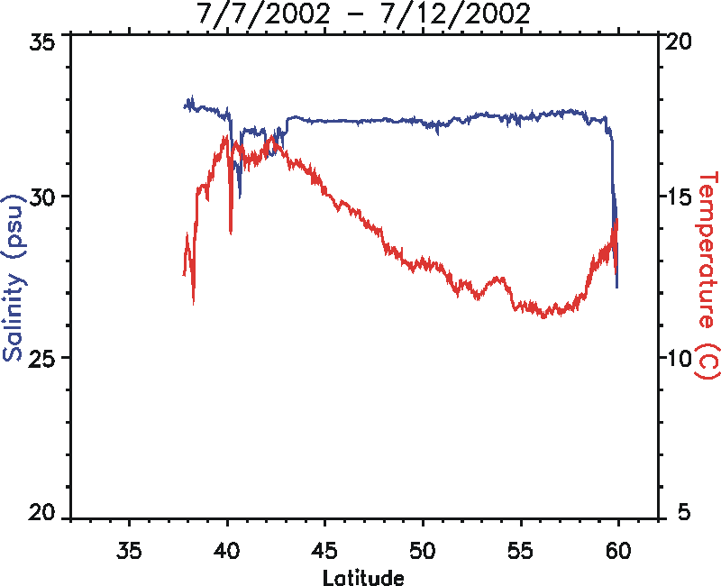
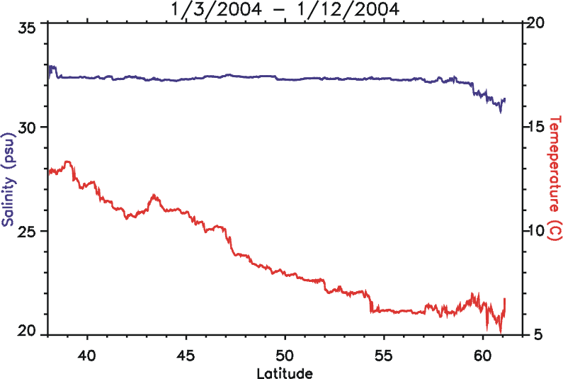
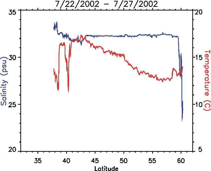
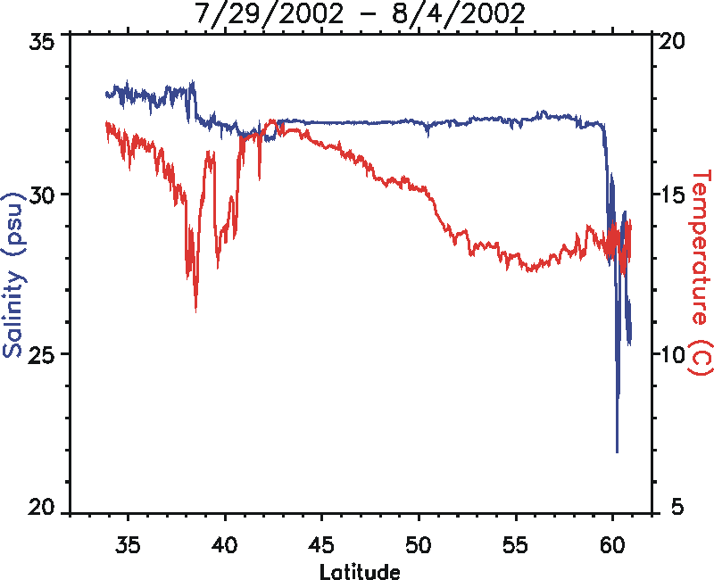
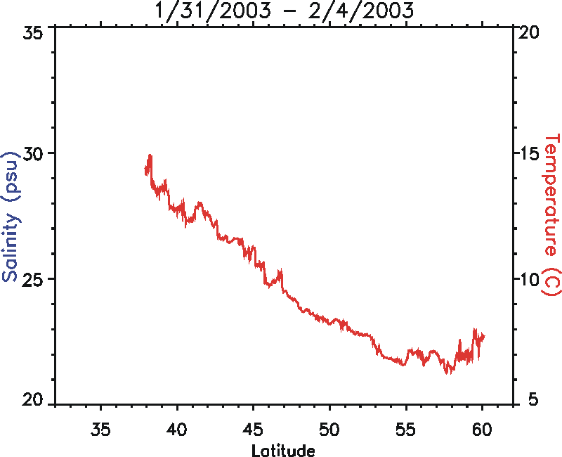
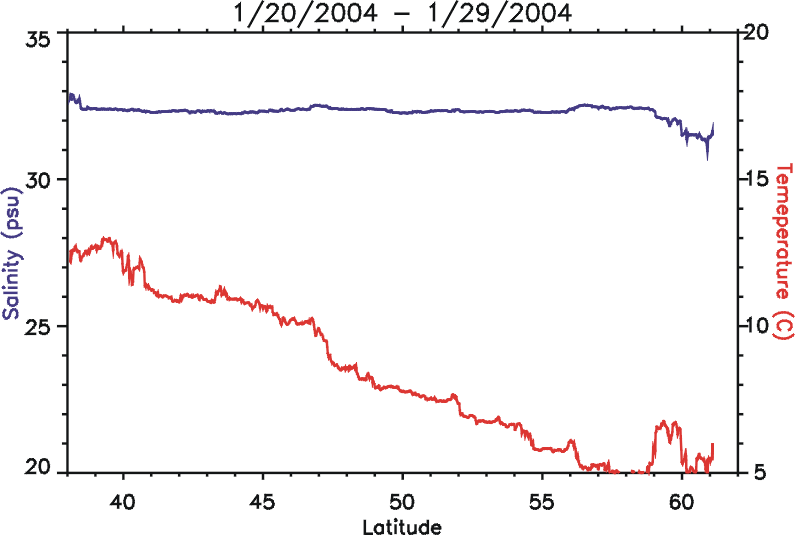
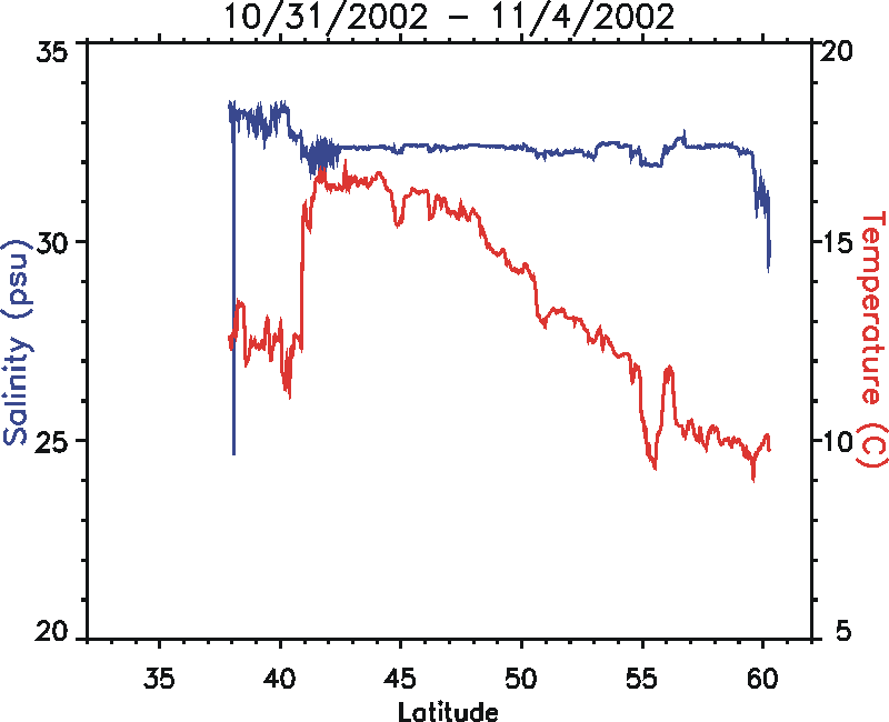
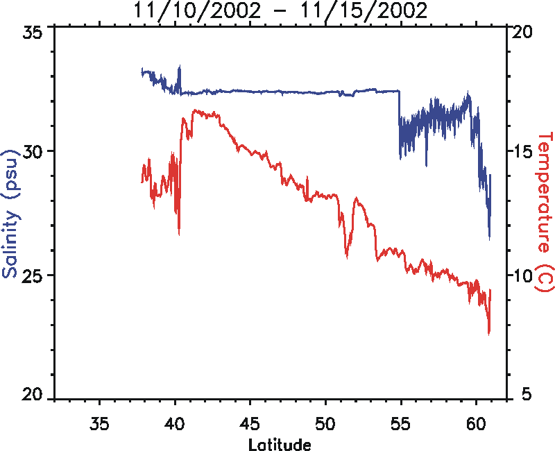
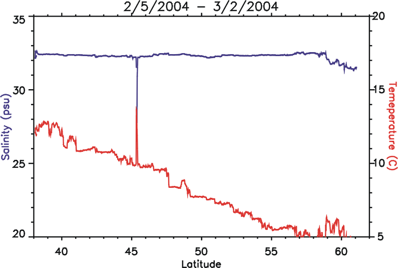
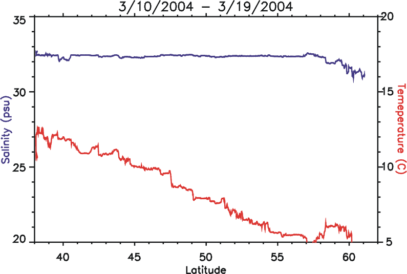
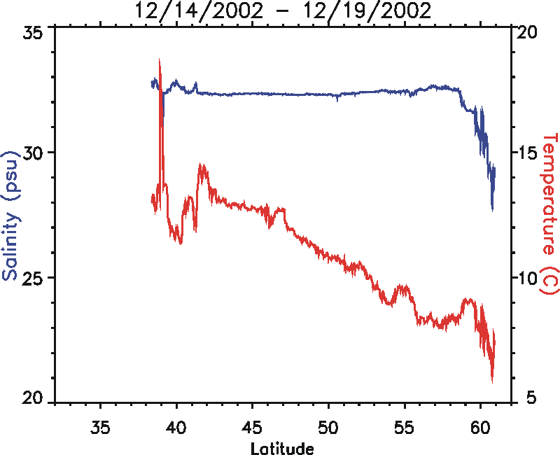
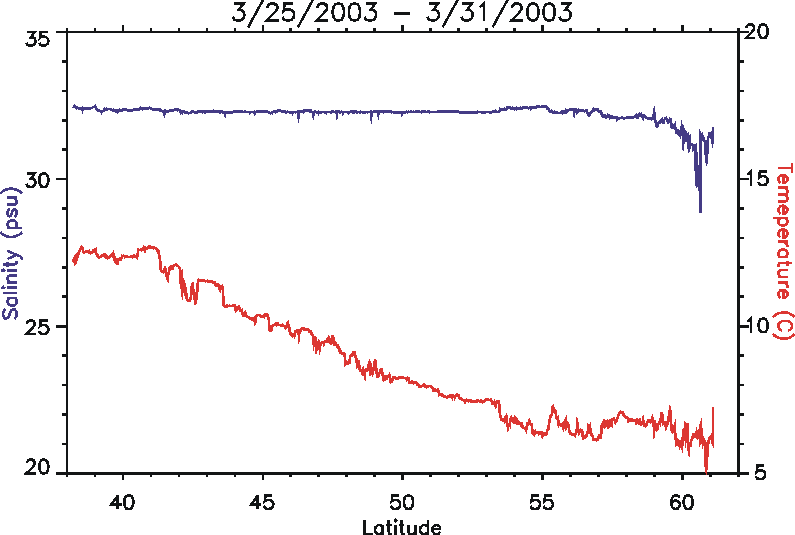
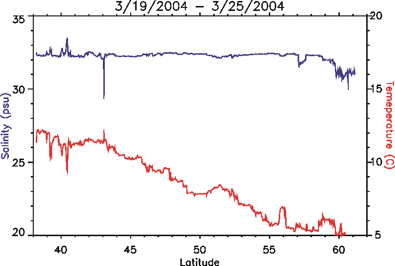
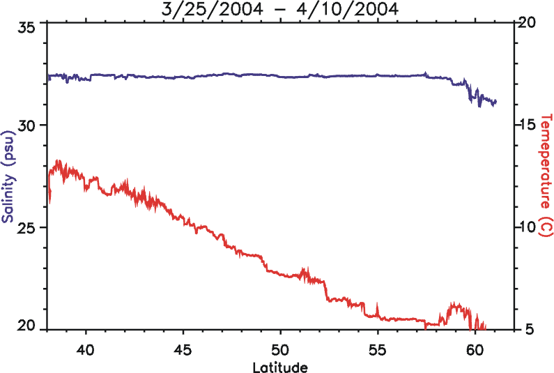
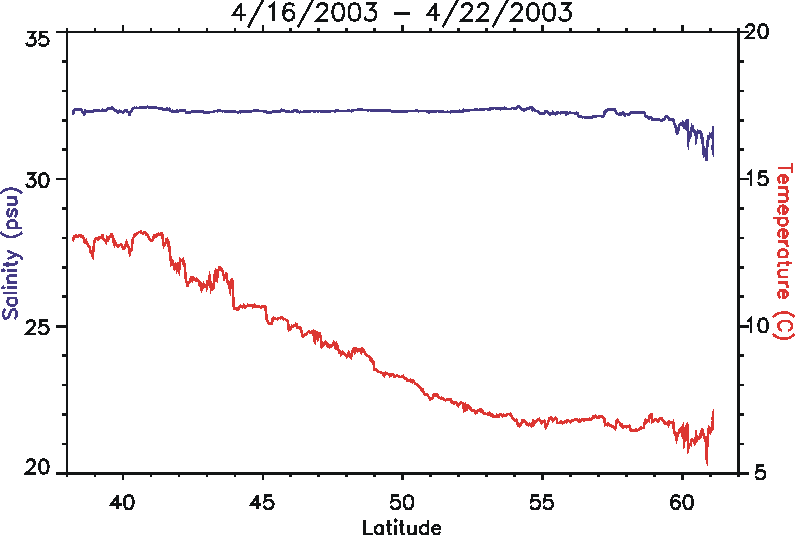
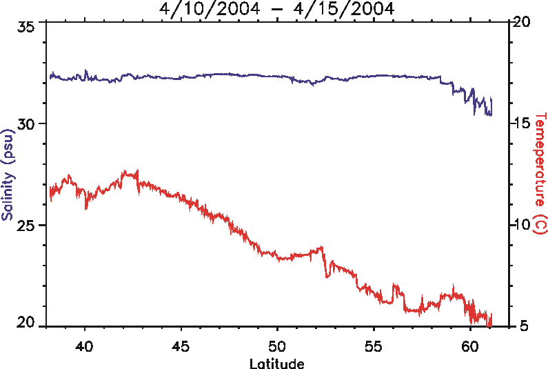
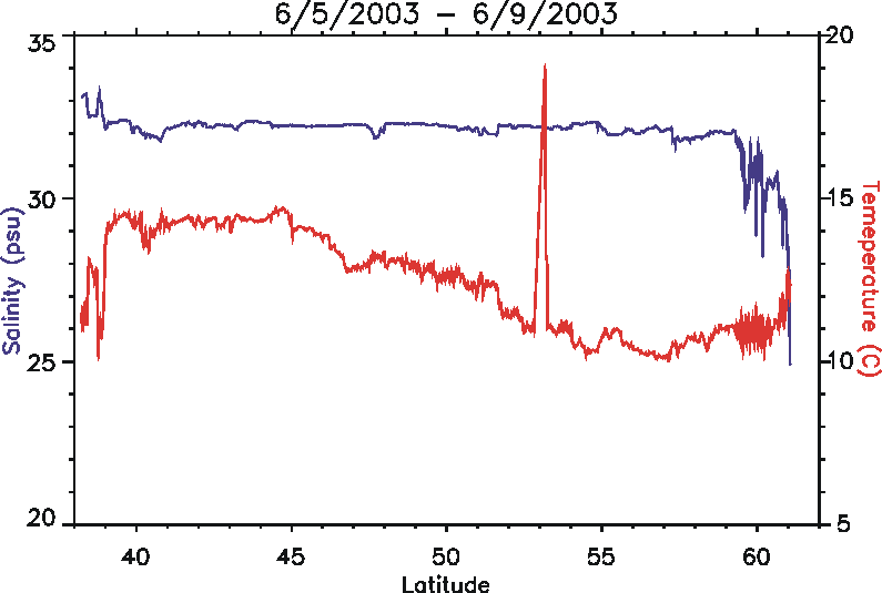
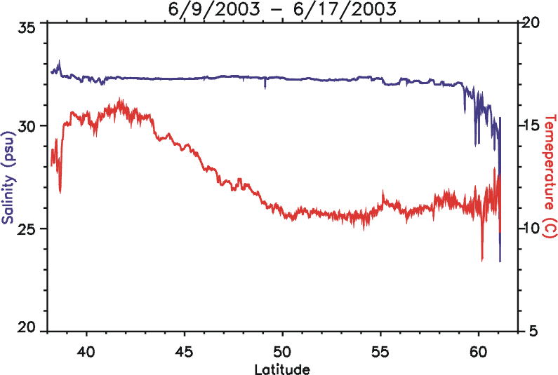
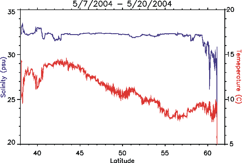
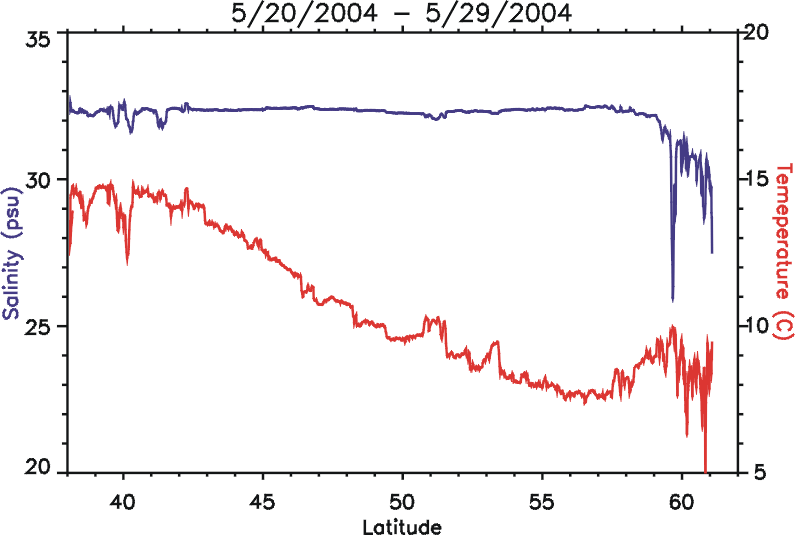
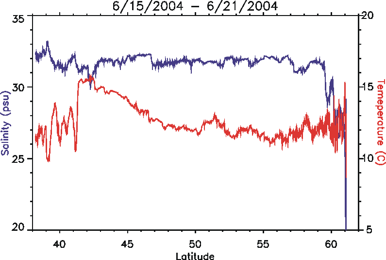
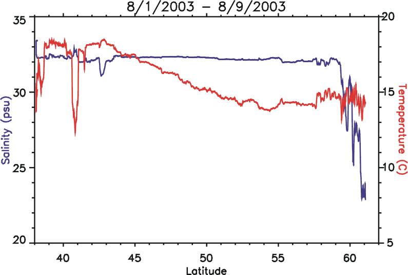
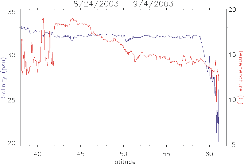
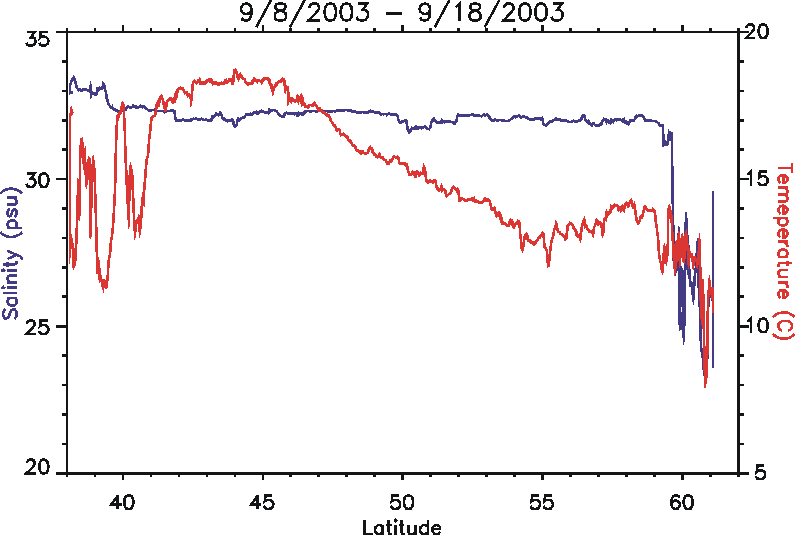
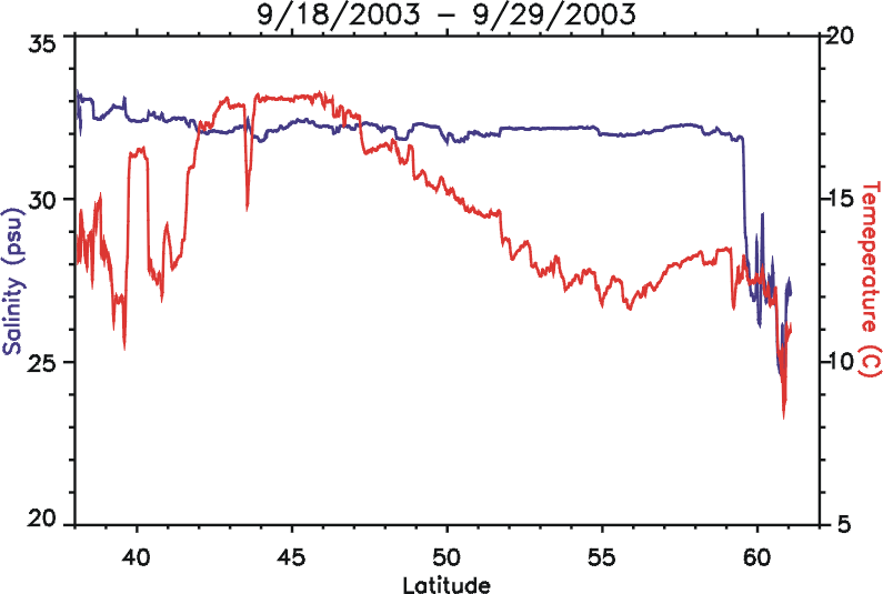
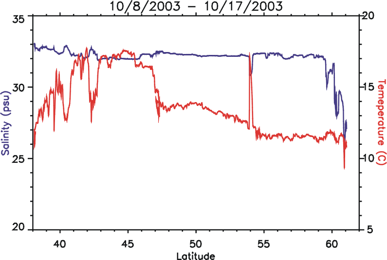
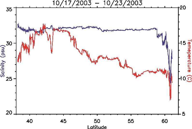
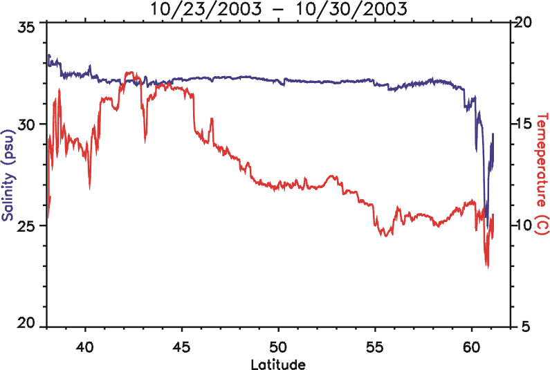
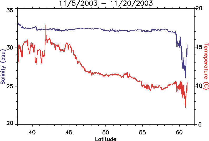
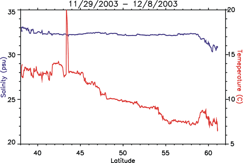
Thermosalinograph data
Plots of near-surface temperature and salinity vs. latitude for each trip between California and Alaska.
Introduction
The observations presented herein are the result of an ongoing two-year, proof-of-concept project to demonstrate the use of a crude oil tanker as platform from which to acquire measurements of oceanographic field variables (near-surface temperature, salinity, and fluorescence) in the Northeast Pacific Ocean.
In order to assess the long-term recovery of marine resources impacted by the Exxon Valdez Oil Spill against the background of climate-driven variability of those resources, long-term measurements of oceanographic conditions are required. Additionally, while the most significant spill-related impacts upon the marine environment occurred in coastal and near-shore domains, the long-term health of those marine ecosystems depends, in part, upon biophysical linkages to the shelf, slope, and open-ocean domains. Consequently, multi-decadal records of oceanic conditions within each of these domains is necessary to develop an understanding of natural and anthropogenic variability in the marine environment of the northern Gulf of Alaska.
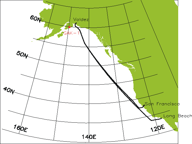
In recent years there has been increasing awareness of large-scale, multi-decadal changes in the climate of the world ocean. However, translating awareness of long-term climate variability into understanding the regional and local physical and biological consequences of a changing environment has been hampered by the dearth of long-term oceanographic measurements in the Northeast Pacific. Presently, the only multi-decadal time series of oceanographic conditions (temperature and salinity) in the region are for Ocean Station P/Line P and station GAK-1 near Seward, Alaska (Figure 1).
 Commercial
cargo vessels operating within established shipping corridors in the Northeast
Pacific are potential ships-of-opportunity from which high-resolution measurements
of oceanographic conditions could be acquired at regular intervals. Crude
oil tankers, travelling between Valdez, Alaska and Long Beach or San Francisco,
California are particularly well suited for this purpose as individual tankers
cross shelf, slope, and open ocean regimes every 10 to 14 days and will continue
to do so for many years to come.
Commercial
cargo vessels operating within established shipping corridors in the Northeast
Pacific are potential ships-of-opportunity from which high-resolution measurements
of oceanographic conditions could be acquired at regular intervals. Crude
oil tankers, travelling between Valdez, Alaska and Long Beach or San Francisco,
California are particularly well suited for this purpose as individual tankers
cross shelf, slope, and open ocean regimes every 10 to 14 days and will continue
to do so for many years to come.
We installed (July 2002) a thermosalinograph (TSG) on the T/V Polar Alaska to acquire high-resolution measurements of near-surface temperature and salinity. A fluorometer will soon be installed to acquire contemporaneous fluorescence (a proxy for phytoplankton biomass).
The objectives for this project are to:
-
Establish a working relationship with the crude oil tanker fleet to use individual tankers as platforms from which to acquire continuous, long-term measurements of oceanographic field variables (e.g. temperature, salinity, fluorescence) along the shipping corridor between Valdez, Alaska and Long Beach, California. Install a thermosalinograph and fluorometer on a tanker to acquire these measurements.
- Identify the seasonal migration and evolution of frontal features associated with the Alaska Coastal Current (ACC), shelf break, and mesoscale eddies.
- Identify the dominant length scales of variability (and seasonal modulation of those length scales) characterizing the near-surface temperature, salinity, and fluorescence fields along the shipping corridor. These scales of variability will likely differ between shelf and the open ocean.
- Compare TSG/fluorometer measurements with TOPEX altimeter observations of the Gulf of Alaska eddy field.
- Compare TSG/fluorometer data with contemporaneous NEP GLOBEC and Continuous Plankton Recorder field data (see also PICES projects).
Brief Description of the TSG system on the oil tanker Polar Alaska
September, 2002
David L. Cutchin (dcutchi1@san.rr.com)
As of 7/2002 the oil tanker Polar Alaska has been carrying a set of SeaBird instruments designed to measure surface water temperature and salinity. The outputs from these instruments, plus the output from a Furuno GPS GP31, are being recorded on a Windows 2000 PC running the NOAA SCS data acquisition and display software.
The SeaBird instruments are a SBE 45 Micro TSG and a SBE 48 Hull Temperature Sensor. Both instruments are housed in rugged, waterproof plastic cases with waterproof connectors. Each one is approximately the size of a shoebox. On the Polar Alaska they are located far aft and down in the engine room near the large sea chest used to draw water for cooling the ships' steam propulsion system. The sea chest intake depth varies between 25' and 42' depending upon cargo and ballast loading.
The SBE 48 hull temperature sensor is magnetically clamped to a flat surface of the sea chest, and it measures the painted metal surface temperature through a thin layer of heat sink compound. The this measured temperature is believed to be "close to" the temperature of the water in the sea chest. On a commercial ship it is not often feasible to penetrate the hull or closely connected piping and measure the water temperature directly.
The SBE 45 TSG is fed seawater from a tap on the high pressure (downstream) side of the "deck seal pump" which draws directly from the sea chest. There is a 1/4 turn ball valve to cut off the TSG flow. There is a coarse strainer ahead of the pump, but a lot of sediments and biological materials reach the TSG especially when the ship is operating in shallow water. Materials building up in the TSG could be a problem. At present there is no debubbler in the TSG feed line. The line from the pump tap to the TSG and from the TSG to the bilge is 3/8 copper tube with SS Swagelok fittings. The engineers do not think that there will be a corrosion problem.
In the line ahead of the TSG there is a clear plastic, 0.2 to 2.5 gallon per minute flowmeter with adjustable "needle" valve (Cole-Parmer SY-32461-07). Originally the needle valve was used to regulate the flow, but it frequently clogged. The engineers discovered that they could more reliably regulate the flow with the ball valve. The outflow from the TSG goes into an open top bucket which is emptied by a sump pump. The flow through the TSG has to be regulated to about 0.2 g/min to avoid overflowing the bucket.
The ship's engineers did the plumbing and the rack for mounting the instruments
in the engine room. Without their enthusiastic assistance this project would
have been ten times more difficult.
As part of normal ship operations the sea chest is flushed continuously with
a dilute solution of sodium hypochlorite to limit biological growth. This
probably will not affect the conductivity measurements, but this should be
tested by cycling the "chloropac" generator off and on when the
TSG is taking data.
The electrical signals from the 45 and 48 are RS-232 serial, which has a limited transmission distance. In order to get the signals up to the engineers office, 250 feet away, there are a pair of optically isolated 232 to 422 (four wire) converters (B&B Electronics 485OTLED).
The 45, 48 instruments and the 232/422 converters are powered by a single 500 ma, 12V brick power supply through four parallel output circuits, each fused at 125 ma. The brick, fused at 1 amp, is plugged into a nearby 110 volt outlet especially provided by the engineers. Occasionally there are brief interruptions in the 110 volt power, but the 45, 48 and converters automatically re-boot into ready states. There is no need for a UPS in the engine room.
The 422 signals to and from the 48 and 45 are passed 250 ft up to the engineers office via a shielded CAT 5 cable which was installed by the ship's engineers. CAT 5 contains 4 twisted pairs which are sufficient for two-way 422 communications with a pair of instruments; two transmit pairs and two recieve pairs). The single shield is used as a "signal ground" for both instruments.
The data acquisition PC, running Windows 2000, is located on a spare desk in the engineers office. The PC is equipped with an optically isolated 422 to serial PCI board (B&B Electronics 3PCIOSD2A). There is no straight through ground path from the engine room to the engineers office; everything is isolated. To the SCS software the board driver makes the 45 and 48 signals look exactly like they come from standard com ports. The 232/422/232 conversions are completely transparent to the SCS software.
The Furuno GPS GP31, located in the engineers' office, communcates with the PC through another serial port. The GPS antenna is mounted inside the engineers' office up against the window glass. The GPS is able to receive signals from enough satellites to enable it to compute fixes most of the time. On this ship it would be difficult to relocate the GPS antenna to a more favorable location.
The GPS and PC are powered through a Powerstar PS500 UPS. This is one of the few UPSs approved by Polar for use on their ships. The 120 V AC power on ships typically has two hot leads, instead of one hot and one neutral. Common UPSs and surge protectors used with land power may burn up when used with ships power.
Data acquisition, logging and display are accomplished using the SCS (v 3.3) software by NOAA. "SCS" stands for "Shipboard Computing System". It was designed for more elaborate shipboard systems where a central data acquistion computer serves several networked computers. But SCS works fine for a single data acquistion computer. The learning curve is not very steep if one only wants to record data from common instruments like TSGs and GPSs. However, SCS also provides a lot of fairly advanced features if one wants to use them. There is a good manual. The key to using SCS is building the correct configuration files for one's computer and instruments. The manual plus the on-screen dialog boxes are probably enough to lead one through the process of creating the configuration files from scratch. The SCS software package also contains some sample configuration files.
The Furuno GPS GP31 automatically outputs several standard NMEA data sentences each second. On the Polar Alaska SCS is configured to acquire and record a couple of standard sentences every 5 minutes - which is often enough for this project. The sentences contain lat, lon, date and time plus some data quality indicators.
The SBE 45 TSG has an internal jumper which is factory set for "Autopower". This jumper was not changed, in part because opening the case would have raised the risk of condensation. Using Hyperterm, the 45 is set to "Autonomous Mode" with a sample interval of 5 seconds. SCS is configured to acquire and record the TSG data (temperature, conductivity and internally computed temperature) every 5 minutes.
Using Hyperterm, the SBE 48 hull temperature sensor is set to Serial Line Synch Mode. In this mode the 48 sends data when SCS sends a polling command - which it is configured to do at 5 minute intervals.
In the near future a WET Labs WETStar Miniature Fluorometer will be inserted in the water line to the TSG.